Student: Giancarlo Nisi
Title of thesis: “Il progetto di recupero e la tecnica del Construction Management: ll caso studio dell’Ospedale San Luigi Gonzaga a Orbassano”
Degree course: Building engineering at Politecnico di Torino
Period: October, 2016
Abstract
The thesis aims at analysing the case study focusing on the recovering of a hospital building, made of complex structures characterised by different levels of degradation; within the present study it was fundamental to take into account the need to continue the activities within the hospital. For this reason, a great attention was paid to the development of the particular construction site, analysing the best possible solutions. Another goal of the thesis is testing BIM in this specific and difficult case study, in order to estimate pros and cons of this methodology, starting from the analysis of the state of art and degradation until the modelling and finishing with the Construction Management. This way, the project has to be analysed deeply, facing all the different aspects of the design phase.
Student: Giosuè Pier Carlo Bronzino
Title of thesis: “Casa Bossi, un «Cantiere di bellezza» rilievo LiDAR e metodologia BIM nella progettazione del ponteggio di facciata”
Degree course: Building engineering at Politecnico di Torino
Period: December, 2016
Abstract
The planning of the “Construction Yard of Beauty” of Casa Bossi in Novara is an opportunity for comparison among various disciplines of architecture and engineering: metric survey and laser scanning, 3D modeling, site safety, building production, scaffolding design and related structural analysis. The management of technical information coming from different areas is carried on using BIM method. Within this thesis, the BIM methodology was applied to the case study, a building designed by A. Antonelli which represents a significant element of Novara’s architectural heritage; the historical value of the building is highlighted by the use of an H in front of BIM, which means Heritage. The thesis aimed at creating a system, used in this specific case for the yard’s phases, open for use and integration with other applications.
Student: Ivan Mascolo
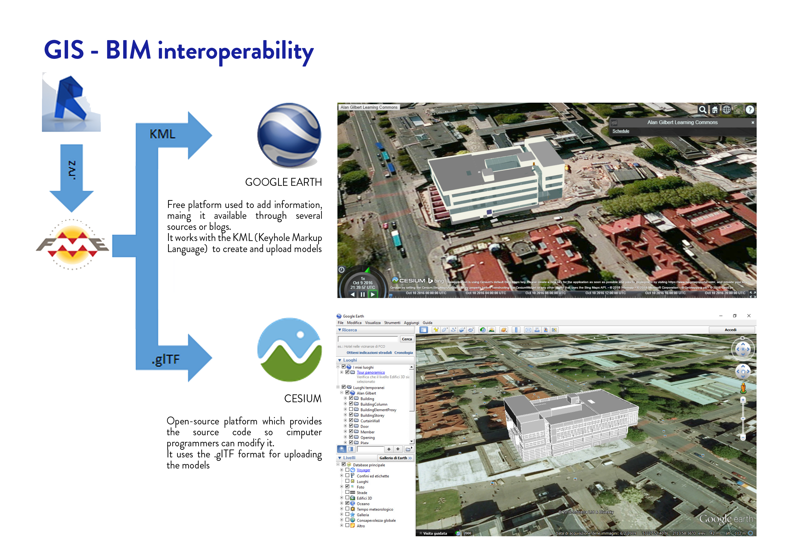
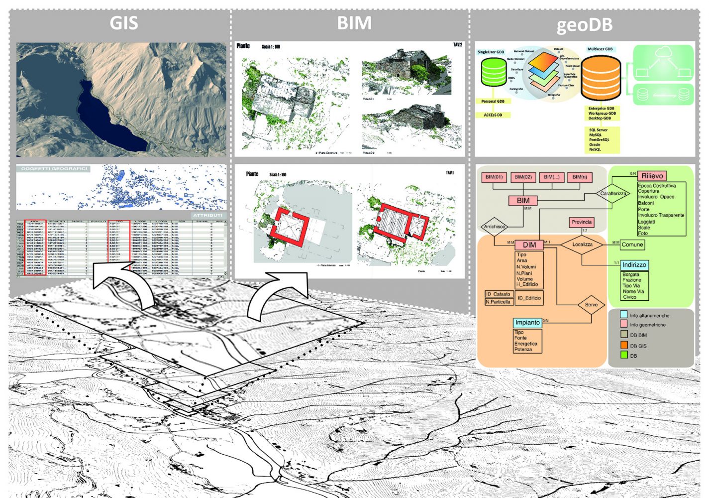
Title of thesis: “DIM and interoperability BIM-GIS for energy saving at urban scale”
Degree course: Building engineering at Politecnico di Torino
Period: October, 2016
Abstract
Today the complexity of work has increased exponentially with the connected issues about the documentation to produce to make a project approved and all of this must be done in the shorter time possible. The functionality of the Building Information Modelling (BIM), based on the parametric modelling software Revit, seems to be the solution to these very complex issues as far as the timing and performance are concerned. Furthermore, the interoperability between BIM and GIS (Geographic Information System) is very interesting; for this reason, the present work is focused on the definition of a possible method to visualize BIM models on GIS platforms, using open-source platforms such as Google Earth and Cesium.
Student: Paolo G. Di Pinto
Title of thesis: “DIM and VR for the users’ awareness”
Degree course: Building engineering at Politecnico di Torino
Period: October, 2016
Abstract
Nowadays, the topic of energy saving is becoming increasingly important. Cities evolve and try to avoid energy dispersion and to diversify sources of energy, in order to reduce carbon dioxide emissions. To analyse these changes, we do not just look at a single building but we should have a glance on the whole, in order to be able to evaluate the best design choices. This thesis focuses on raising awareness of users on a conscious use of energy sources to give guidelines to achieve energy savings. To do this, energy analysis techniques at the district level are used, producing models with similar characteristics to the reality. Moreover, it was decided to develop an application on a multimedia platform on personal computer. Unity3D is a development environment for video games with a very simple method: it is suitable for all types of work groups, both small and great. Inside Unity we can find all main tools that are necessary for the creation of a video game as the animation tool, the materials manager tool and a ground one with which we can create trees and any environment. The gamification approach was tested to involve the users within the process of the DIMMER project.
Student: Federico Bava
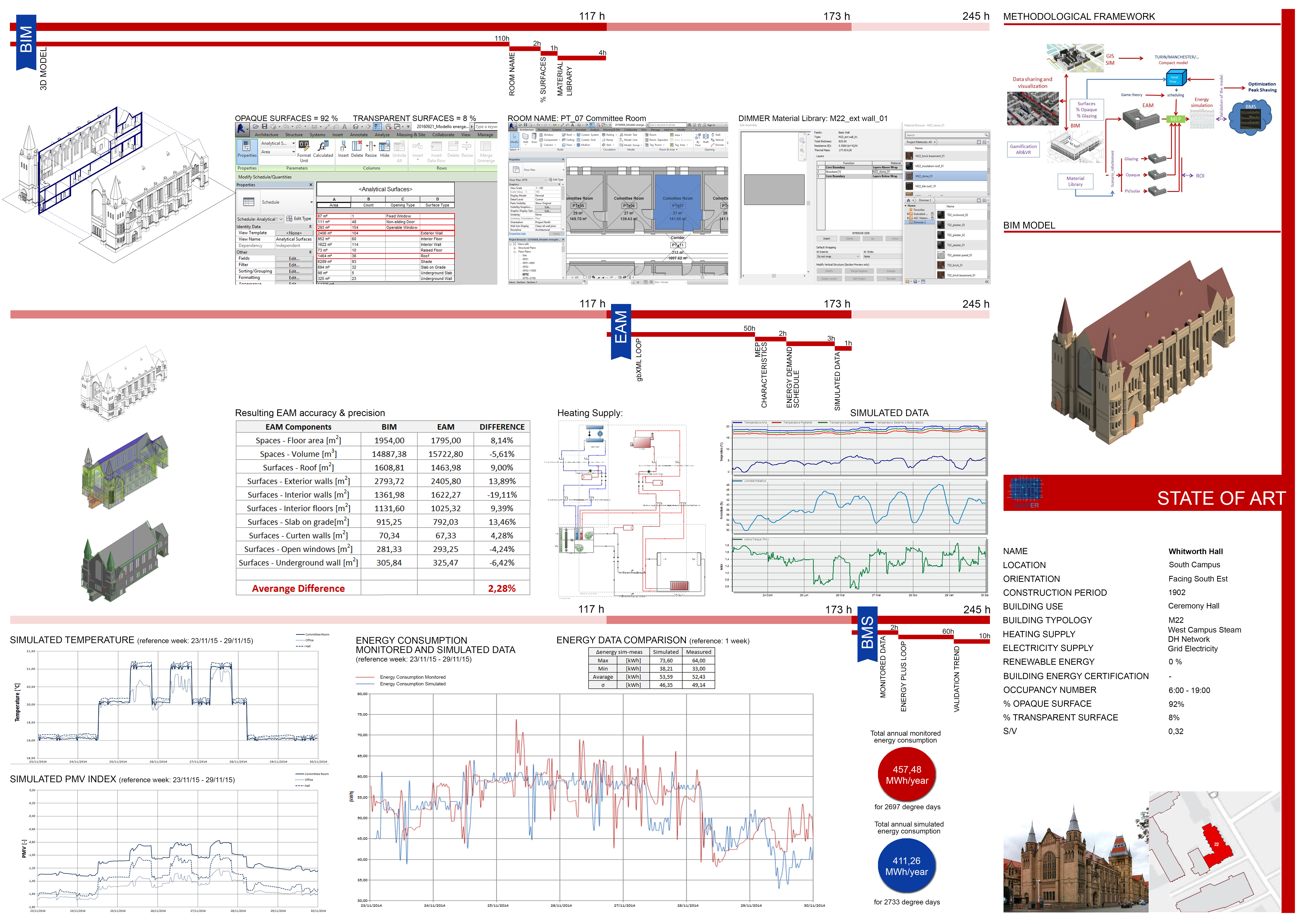
Title of thesis: “The energy saving at urban scale with DIM: The Whitworth Hall”
Degree course: Building engineering at Politecnico di Torino
Period: October, 2016
Abstract
Energy saving is one of the main objectives of last years; for this reason, a lot of methods have been developed and applied. The main purpose of this master thesis is to present the urban scale application of BIM (Building Information Modelling) under the European DIMMER project. The aim of this project is to reduce the energy consumption of existing buildings and the real-time monitoring of some parameters such as the trend of the internal temperature, relative humidity and the environmental comfort. In this master’s thesis I tried to achieve the prearranged objectives of the DIMMER project, using only the potentiality of the BIM methodology. The energy analysis of parametric models has been useful to analyse the systems energy consumption, the internal temperatures profiles and the environmental comfort conditions. The results obtained were compared with real data monitored inside the building. This comparison allows to validate the process applied and consequently establish that the parametric model has been created correctly.
Student: Stefano Giovannitti
Title of thesis: “BIM, Augmented and Virtual Reality for Maintenance”
Degree course: Building engineering at Politecnico di Torino
Period: March, 2016
Abstract
The thesis talk about the application and the analysis of Augmented Reality (AR) and Virtual Reality (VR) for the visualization of the data regarding elements maintenance by using Building Information Modelling (BIM) for plant–engineering modeling.
This work in based on an analysis of documents, publications and website forum that allowed to develop and improve some new existing technologies in the market.
In conclusion , the main goal consists of the evaluation of the utility and the advantages of BIM–MEP and the results visualization with Augmented or Virtual Reality.
Student: Eliana Miglietta
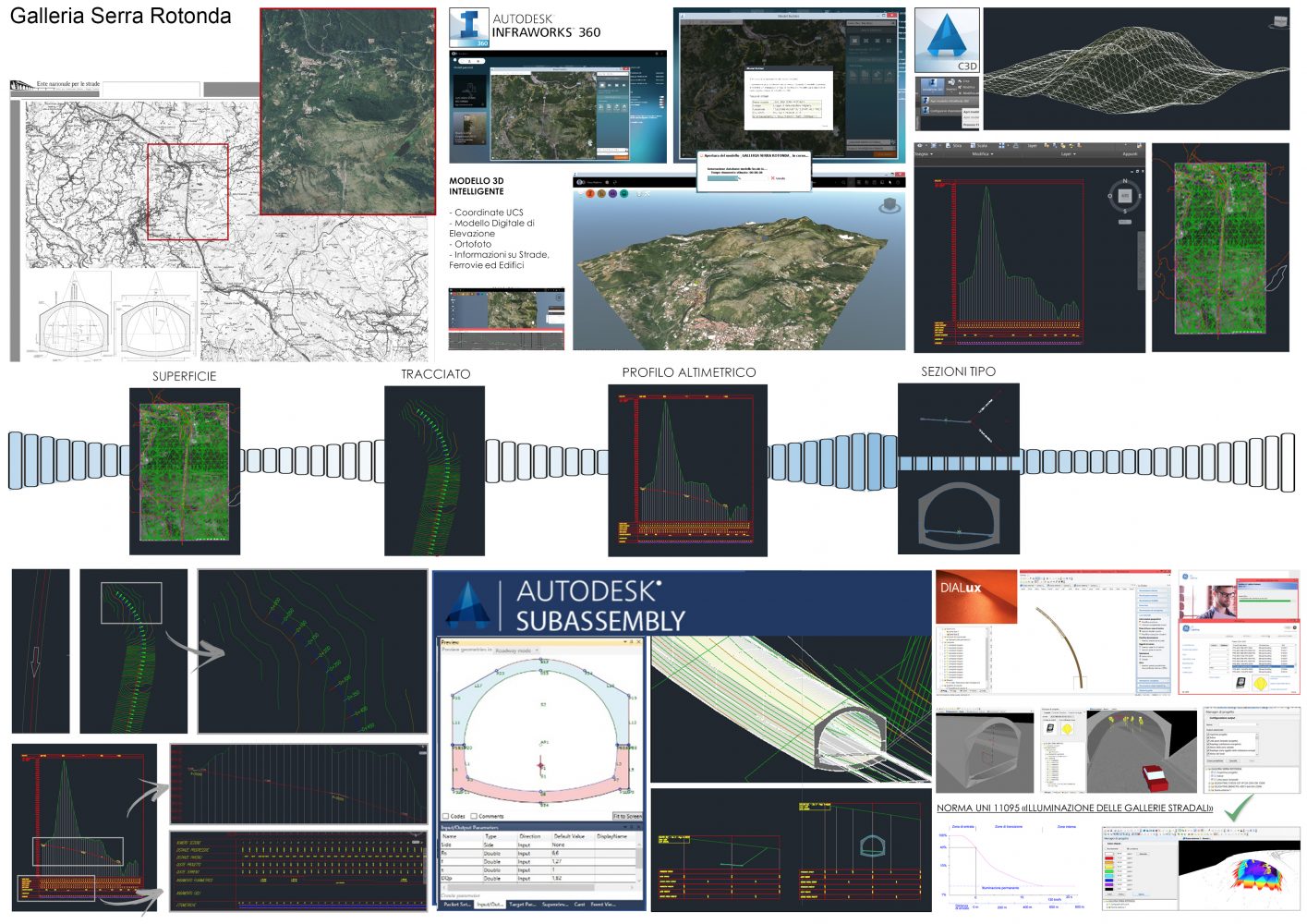
Title of tesi: “The BIM methodological approach applied to road infrastructure: case study Serra Rotonda Tunnel”
Degree course: Architecture at Politecnico di Torino
Period: February, 2016
Abstract
The aim of my thesis work is to test an innovative approach based on Building Information Modelling (BIM) methodology for Infrastructure design. Starting from. the documentation provided by A.N.A.S, the company that manages the Italian road and motorway network, it was possible to test the process by referring it to a particular case study: Gallery Serra Rotonda of the new A3 motorway in Basilicata.
My interest on the subject is due to the fact that BIM methodology should provide an important opportunity for process optimization, as well as to facilitate the project, introducing higher quality and at the same time a cost saving. Thanks to a management of the entire life cycle, all the projects that use a BIM based approach allow to evaluate different scenarios, identify and anticipate risks and opportunities acting in real time.
After careful analysis of documentation provided by ANAS, thesis work is divided into three main phases:
- Testing the Interoperability approach between different software as Civil3D, Infraworks, Revit, Dialux, in order to improve the collaborative activities and data sharing.
- Definition of LEVEL of Development and DETAIL ( LOD ) concepts, in order to organize the geometrical and alphanumeric information and their recognition relating to infrastructure matters.
- Definition of the Standards for the creation of a common language that defines precisely the exchange of data on the basis of the cooperation of the BIM group work.
After the initial activation that took time, planning and training, it tried to give an overview of how it’s possible to start to use a BIM process, reason why the modeling of the case study does not go into detail regarding structure, plants and system.
Student: Simona Barone
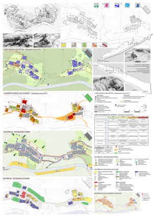
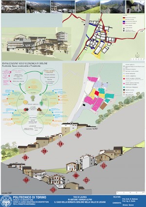
Title of thesis: “Ri-Abitare i borghi alpini – il caso della borgata Serlone nella Valle di Locana”
Degree course: Architecture at Politecnico di Torino
Period: September, 2015
Abstract
Testing BIM on Serlone, in Locana Valley, had the aims to provide an alternative and transferable method to design and modeling hamlets through parametric software and offer suggestions to use the model during the phases of recovery.
Thanks to the management and elaboration of the inserted graphic data in the model, it was possible to obtain a general complete framework of Serlone’s real state representing the starting point to set up recovery projects.
The idea of creating a “library” of technical elements of traditional alpine architecture was born to satisfy the following needs:
– to supply Revit families for mountain architecture (doors, windows, chimneys, railings, etc.) downloadable from web;
– to support other alpine technicians both in modeling and project phases to avoid alterations and falsifications of common typology of the alpine building tradition.
Despite the longer time needed to model by BIM respect to traditional CAD, it is possible to observe the BIM’S advantages on the long period for the information management and the documents processing, especially in urban projects, where there are many data to control and coordinate.
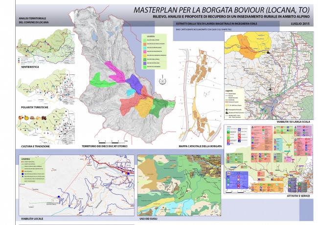
Student: Michele Prono
Title of thesis: “Masterplan for the village Boviour, Locana (TO). Survey, Analysis and recovery proposals of a rural settlement in alpine area”
Degree course: Building engineering at Politecnico di Torino
Period: July, 2015
Abstract
Counteracting the abandonment of alpine rural villages, the depopulation of the mountains and the abandonment of traditional culture of the built environment are important activities for the preservation of the historical and cultural heritage of these places. The aim of this work was finding the potentialities of Boviour, as part of the system of 92 historic villages of the Comune di Locana in Valle dell’Orco, through a territorial analysis and a survey of the present conditions of the village, in order to produce sustainable recovery hypothesis. The inclusion of an “albergo diffuso”, a formula made in Italy and increasingly widespread, is among the solutions studied, identifying Boviour as part of a “larger urban complex”, Locana territory. Another interesting case is the breeding of goats, important for the protection of undergrowth. The technology of 3D printing, increasingly widespread in the fields of urbanism and architecture, has also been applied during the search process.
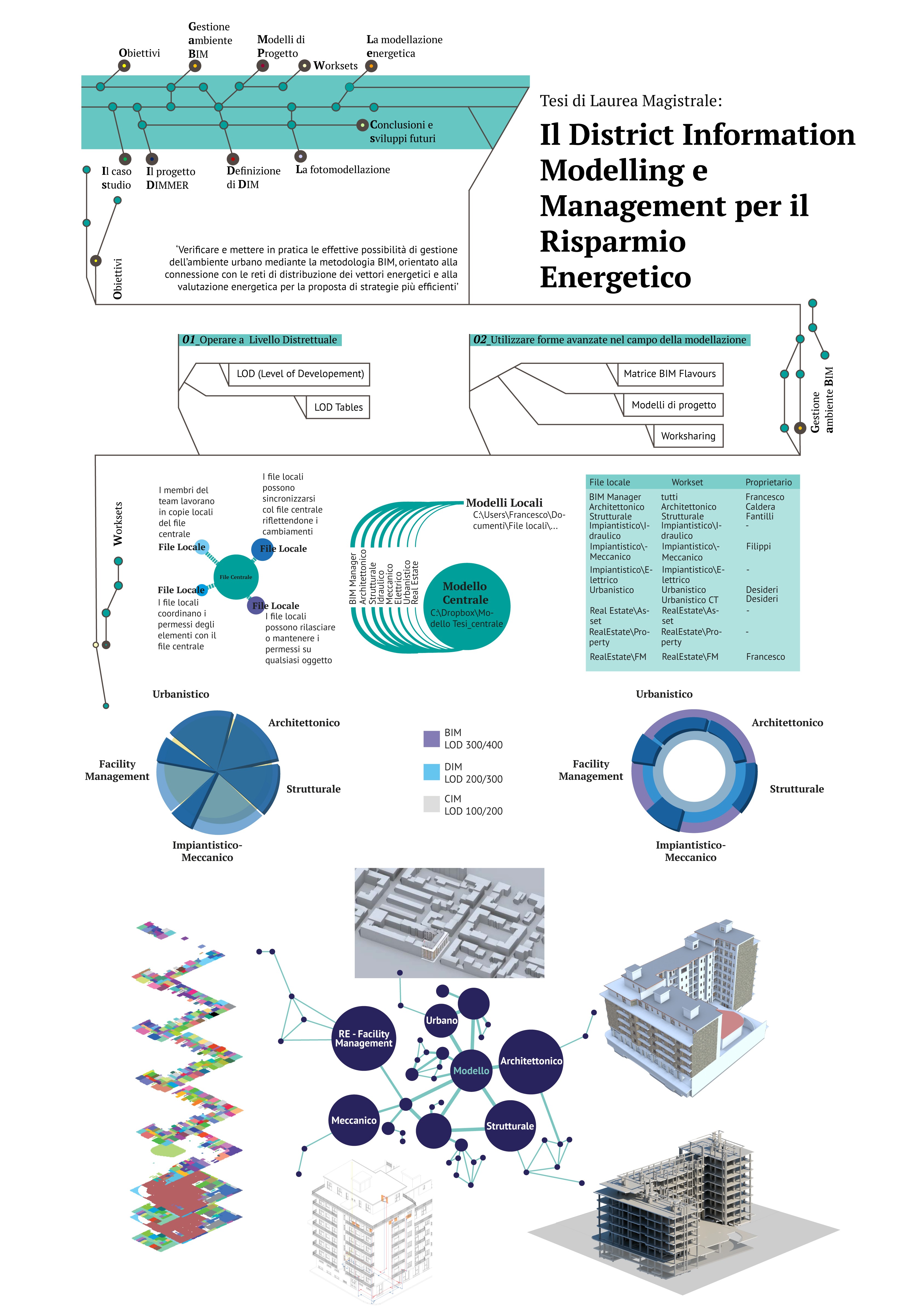
Student: Francesco Semeraro
Title of tesi: “District Information Modelling and Management for Energy Reduction”
Degree course: Building engineering at Politecnico di Torino
Period: December, 2014
Abstract
The main purpose of this work was to verify and to apply the effective possibilities to manage the urban environment by using BIM methodology, oriented to the connection to the district energy distribution and to the energy analysis for the proposal of more efficient strategies of governance. The case study was a residential building in Turin, which is also a DIMMER’s case study, an European research project about BIM and energy saving. To obtain the predicted goals was important to manage the BIM environment related to: operate on a district level (LOD, LOD Tables) and the use of advanced methodologies in parametric modelling (BIM Flavours matrix, Project Templates, Worksharing). Defined DIM, it was possible to create the parametric model according to the LOD of district models. Project template was very useful for the cooperation of different AEC actors whose can participate at the district modelling, in particular using worksets option that enables worksharing in Revit environment. Helpful during the modeling phase was the Photomodelling technique, which permits to obtain elevations and plants using a pixel cloud derived from a photographic survey. It was also developed a dynamic simulation of building consumptions using DesignBuilder.
Student: Niccolò Rapetti
Title of thesis: “Energy Park a vector of knowledge for transformation SMART of a territory”
Degree course: Architecture at Politecnico di Torino
Period: July, 2014
Abstract
The project Energy Park (EP) aims to face the depopulation of mountain areas getting involved key stakeholders, such as the Gran Paradiso National Park (PGNP), Iren and the community of Valle Orco and Soana. In fact, during the last decade the mountain area suffered a significant reduction of population with consequent loss of attractiveness, especially from tourism. In order to reverse the negative trend, a possible option would be to take advantage of the new capital, deriving from “the Structural Funds 2014-2020”, to develop a number of actions such as: Smart Growth, Sustainable Growth, Inclusive Growth.
Following these goals, the Energy Park project aspires to provide new opportunities, developing issues based on SMART NETWORK, through the creation of polygeneration’s system for energy efficiency, improving the exploitation of local resources and at the same time it should reduce the CO2 emissions.
In this way, the Information Communication Technology (ICT) plays a key role for the future of mountain areas. For this reason, one of the main goals is to set up an information platform able to collect heterogeneous data that derives from several domains such as: WEB Application, Device Application, Geographic Information System (GIS), Building Information Modelling (BIM), etc..
Another point of the thesis work is to examine the interoperability among different system, in order to facilitate data sharing through the use of appropriate formats exchange. Hence, starting from GIS domain the information was shared with BIM domain, where thanks to the use of digital photogrammetry was possible to obtain a parametric model. After, all information coming from different data sources were managed by a geospatial information system.
The future developments of my thesis will be the creation of web platform to collect in a single, easily, accessible network, where all information about Orco Valley will be placed, which could be immediately visualized from tourist and locals.
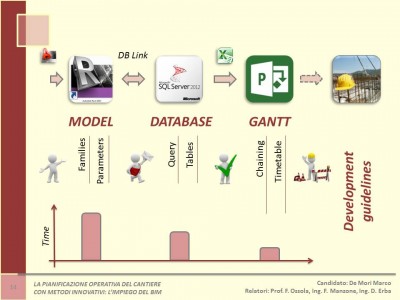
Student: Marco De Mori
Title of thesis: “La pianificazione operativa del cantiere con metodi innovativi: l’impiego del BIM”
Degree course: Building engineering at Politecnico di Torino
Period: March, 2014
Abstract
The goal of this thesis is to investigate what might be the benefits of the Building Information Modeling (BIM) in terms of operational planning, programming and management of the construction site. Developing a 3D parametric model the professional can add a lot of information about the elements enriching the graphical archive. Subsequently, these data can be useful for 4D and 5D simulations.
Another objective is to change the traditional way to construct a building considering the potentiality of BIM to reduce costs and time through a dynamic procedure, optimizing the entire construction process.
The research was conducted through literature review applied to a real case study, the stadium in the city of As Samawah (Iraq). Results demonstrate that a 4D BIM schedule is a derivation of the 3D BIM geometry and an optimization of the resources, and that interoperability must be improved.